Navionics HotMaps Platinum Lake Maps North
NAVIONICS
- SKU
- HMPT-N6-821245115942
- UPC
- 821245115942
- Shipping
- Calculated at Checkout
- Current Stock
- Out Of Stock
Head out with confidence with Navionics HotMaps Platinum Lake Maps. All of the same lakes, content and advanced features found in Navionics+ are augmented with 3D View, satellite overlay and panoramic photos to provide the ultimate situational awareness. Designed with the most demanding boaters and serious anglers in mind, these additional viewing options can be used on a growing number of GPS plotters. Quickly target the best spots and catch more fish with Navionics HotMaps Platinum Lake Maps! Daily updates and advanced features are included for one year. Simply plug your card into your PC/Mac and register at navionics.com. USB reader provided. SonarChart Shading is a new chart feature that is exclusive to Navionics HotMaps Platinum+ and Navionics HotMaps Platinum cartography products for coastal and inland fishing and boating. Embedded with satellite overly content layer, SonarChart Shading provides a detailed rendering of the seafloor and lake bottom to deliver a unique perspective of underwater topography at a glance. Created from the high definition 1' contour data within SonarChart, varying shades of blue reveal changes in depth, highlighting channels, drop-offs and other features to give you better situational awareness, and clear visual cues to identify fish-holding structure. SonarChart Shading can viewed on GPS chartplotters that are compatible with HotMaps Platinum and Platinum+ satellite overlay and with the same options, including selectable overlay on land, land and shallow, or full overlay. Adjustable transparency allows you to view the new imagery blended with either the SonarChart bathymetry map or nautical chart. Features:
-SonarChart Shading -Lake Charts -One foot contours -21,000 lakes and growing -Daily updates and advanced features for one year -Preloaded with Nautical Chart and SonarChart -Community edits are downloadable. -SonarChart Live -Advanced Map Options -Plotter Sync -Enhance SonarChart with sonar logs you collect. -Structures, reefs, drop-offs, vegetation, boat ramps, marinas, safety depth contours, navaids.
Just plug-and-play. SD/MicroSD media cards are pre-programmed and ready-to-use with today's leading chartplotters - including Humminbird, Lowrance, and many more.
Click Here for Navionics' complete listing of compatible units.
Region/Coverage: NORTH - IA, MI, MN, WI, ND, SD
Specifications and Features:
- Country of Origin: United States of America
- Product Model: North
Please Try Again
This webpage is experiencing a large amount of traffic. Please try again later.
Orders ship on business days Monday through Friday, shipments are made within 2 business days. In rare instances a product may require additional shipping time.
Unless a different shipping option is selected, items with FREE SHIPPING under 1LB ship USPS First Class and items between 1-3 LBS ship USPS Priority Mail.
Firearms ordered online from our website ship for free via Fedex. Firearms will be shipped within 48 hours from the time the transfer FFL is received and processed during business days Monday through Friday.
All orders that include ammunition must ship via Fedex Home Delivery or UPS Ground.
Spend $50 in Fishing and get FREE USPS shipping (Free Shipping only applies to Fishing items. Other items in same cart may have shipping applied) Offer valid only in the lower 48
Items with an extraordinary weight or dimensions may be excluded from Free Shipping promotions.
You will receive an email confirmation when your order ships. Please remember that until the carrier scans the package your tracking number will not work. Please allow up to 24 hours for tracking number to be activated.
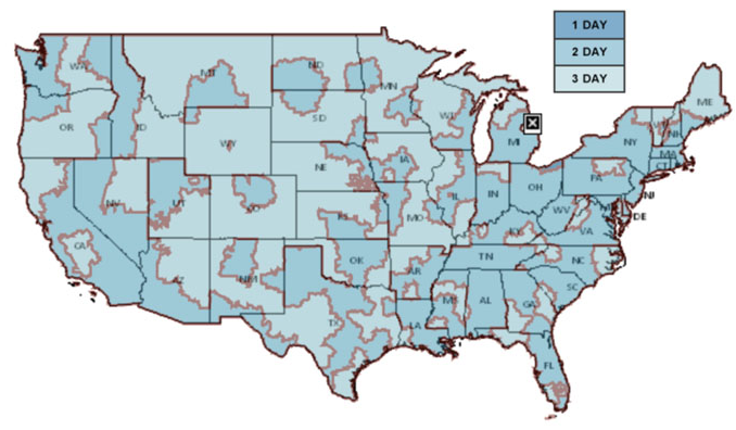
USPS PRIORITY MAIL DELIVERY TIMES (Estimated)

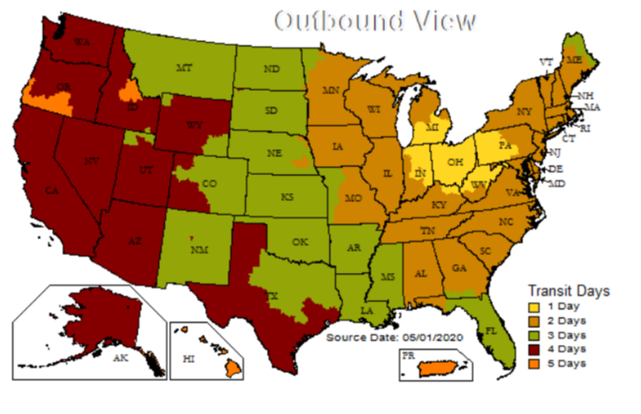
UPS GROUND DELIVERY TIMES (Estimated)


